Godzilla El Niño Threatens Global Weather Extremes
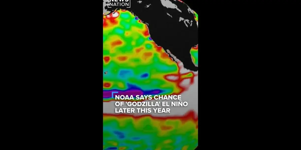
NOAA models show a significant chance of a "Godzilla" El Niño forming this year, a rare and powerful weather event. This could lead to extreme global weather, including flooding, wildfires, and heatwaves. Scientists are closely monitoring the situation, with peak impacts expected between October and December.
Godzilla El Niño Threatens Global Weather Extremes
Scientists are watching a rare weather pattern with concern. Climate models from NOAA, the National Oceanic and Atmospheric Administration, suggest a strong possibility of a “Godzilla” El Niño forming this year.
This type of El Niño is not common, having been recorded only three times in history, with the most recent event occurring from 2015 to 2016. Such a powerful El Niño could lead to significant shifts in weather patterns all around the world.
Normally, warm ocean waters in the Pacific Ocean travel towards Asia. However, during an El Niño event, these warm waters shift eastward, moving toward South America.
This change affects weather systems across the globe. For the United States, this typically means warmer temperatures nationwide and increased rainfall, especially in the Southwest and Southern regions.
What Makes This El Niño Different?
The term “Godzilla” El Niño refers to a particularly intense version of the event. In these extreme cases, the Pacific Ocean’s surface temperatures can rise by as much as 2 degrees Celsius above average. This significant warming of the ocean can fuel more severe weather impacts.
Higher chances of extreme weather events become more likely. These include severe flooding, which can cause widespread damage to communities and infrastructure.
Increased risk of wildfires, particularly in regions already prone to them, is a serious concern. Extreme heat waves, posing dangers to public health and straining power grids, are also a potential outcome.
Global Impacts Beyond the US
The effects of a strong El Niño are not confined to one country. This weather phenomenon truly acts as a global driver of change. Nations across different continents can experience unusual weather conditions, from droughts in some areas to excessive rainfall in others.
Understanding these global connections is vital. For example, a strong El Niño in the Pacific can influence monsoon patterns in Asia, affecting agriculture and water supplies for millions. It can also impact hurricane seasons in the Atlantic and influence temperature and rainfall in Europe and Africa.
Current Predictions and Uncertainty
While the predictions are concerning, it’s important to remember that climate models are not perfect. Meteorologists emphasize that it is still early in the year, and the models could change as more data becomes available. The current forecasts from NOAA indicate a 61% chance of an El Niño developing by this summer.
The probability of this El Niño reaching “super” or “Godzilla” strength is highest between October and December of this year. This timeframe suggests that the most intense impacts might be felt in the latter half of the year and potentially into early 2025. Scientists will continue to monitor the situation closely.
Why This Matters
The potential for a “Godzilla” El Niño highlights our planet’s sensitivity to ocean temperature changes. These shifts can disrupt weather patterns we often take for granted, leading to costly and dangerous consequences. From agriculture to disaster preparedness, understanding and anticipating these events is crucial for many sectors.
For communities worldwide, early warnings and preparedness measures can save lives and reduce economic losses. Businesses, governments, and individuals need to consider the potential impacts on everything from food prices to insurance rates. Being aware of these climate predictions allows for better planning and adaptation.
Historical Context and Future Outlook
El Niño events have been observed for centuries, with indigenous peoples in South America likely noticing their effects long before modern science. The term “El Niño” itself, meaning “the little boy” or “Christ child” in Spanish, was used by fishermen off the coast of Peru to describe the warm ocean current that appeared around Christmas.
The last strong El Niño, from 2015-2016, brought significant weather events, including severe droughts in parts of Africa and Australia, and heavy rainfall in California. Studying past events helps scientists refine their models and improve predictions for future occurrences. The increasing frequency or intensity of extreme El Niños could be linked to broader climate change trends.
The future outlook suggests that as the planet continues to warm, the interactions between the ocean and atmosphere may become more volatile. This could mean more frequent or more intense extreme weather events, including powerful El Niños. Continued investment in climate monitoring and research is essential for understanding and responding to these challenges.
NOAA will continue to issue updated forecasts as the situation develops. Residents in areas typically affected by El Niño should stay informed about local weather advisories and prepare for potential extreme conditions.
Source: NOAA models show the potential of a ‘Godzilla’ El Niño this year | NewsNation (YouTube)
Related Articles
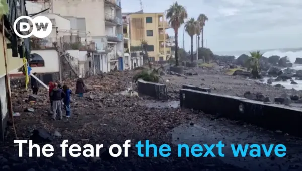
Italy Storm Fury: Family Survives 10m Waves in Sicily
Cyclone Harry battered Sicily in January 2026 with 10-meter waves, leaving a path of destruction and fear. Residents narrowly escaped disaster, highlighting the dangers of coastal development in the face of rising sea temperatures and extreme weather. While some communities are exploring innovative protection methods, the future remains uncertain without significant policy changes.

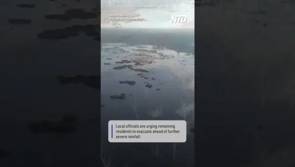
Wisconsin River Swells to Crisis Levels, Forcing Evacuations
The Wolf River in Shiocton, Wisconsin, has reached historic flood levels, forcing officials to order evacuations. Drone footage shows the river has spread far beyond its banks. Forecasters predict more rain, worsening the situation and highlighting the need for disaster preparedness.


Michigan Floods Open Chasms, Swallowing Cars Whole
Severe flooding in Fremont, Michigan, caused roads to buckle and dangerous sinkholes to open up. One car was swallowed by a newly formed chasm, highlighting the hidden dangers of extreme weather events. This incident serves as a stark reminder of the need for improved infrastructure and disaster preparedness.