China Maps Oceans, Raising Fears of Future War
China's extensive ocean mapping efforts across strategic global waters are raising alarms among US officials. Experts suggest this data collection, while claimed as scientific, could significantly boost China's submarine warfare capabilities and alter the balance of power in contested regions.
China Maps Oceans, Raising Fears of Future War
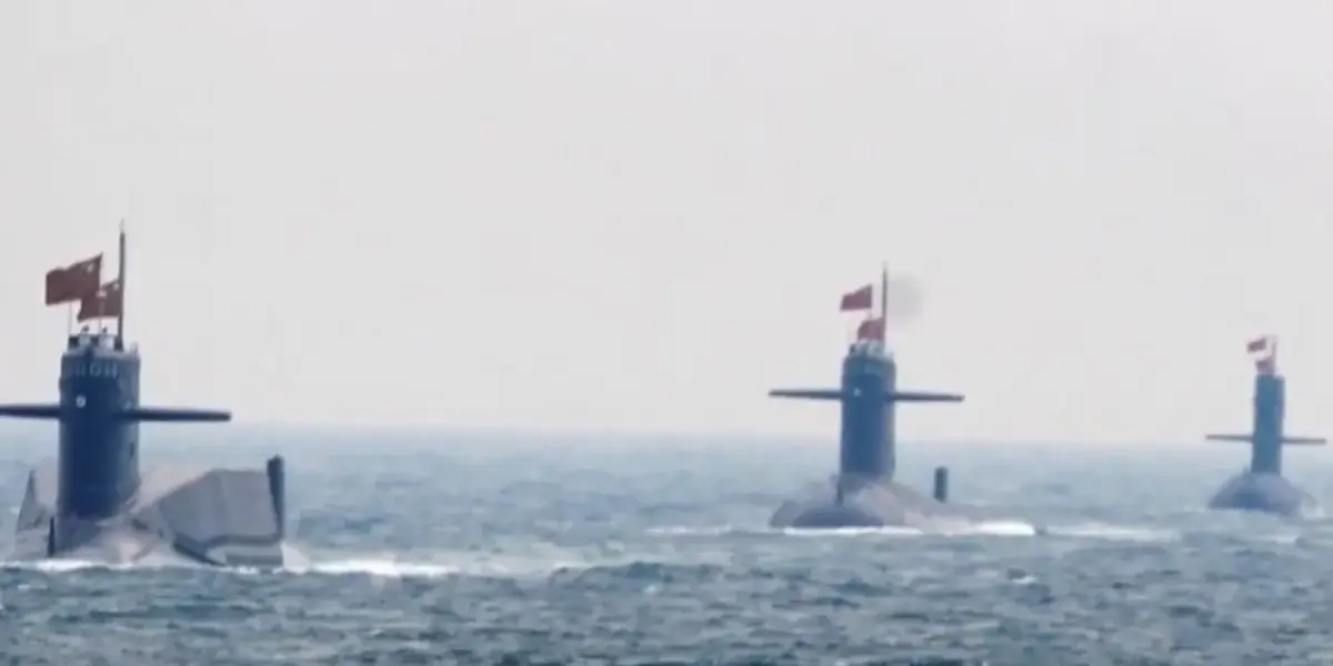
New reports show China is quietly mapping the world’s oceans. This effort is causing worry among US officials. They suggest it could be preparation for a future conflict with Washington. China is using many research ships and hundreds of sensors. These tools are gathering detailed information across the Pacific, Indian, and even Arctic oceans.
This collected data could give China a big advantage in submarine warfare. A recent Reuters report highlighted that China’s mapping efforts cover some of the most important waters globally. This includes areas close to Taiwan, Japan, and Guam, a key US military base. One specific research vessel was seen sailing repeatedly through these areas and near the Malacca Strait. This strait is a vital route for global trade, making its mapping particularly significant.
China officially states these missions are for scientific research. They claim the work focuses on things like climate studies and surveys of the seabed. However, experts believe this same data has clear military uses. Detailed maps of the ocean floor are crucial for submarines. They help these underwater vessels move more easily, stay hidden from detection, and track enemy ships more effectively. The use of underwater sensors further enhances these capabilities, providing real-time information about the marine environment.
US intelligence officials have noted that China has increased these mapping operations significantly in recent years. This increase is fueling concerns about the potential military applications of the gathered information. The scope of China’s mapping is also extensive, reaching far beyond the Pacific. It includes important energy routes in the Indian Ocean. The efforts even extend into the Arctic region, where China has expressed ambitions to become a major global power. As China continues to gather this vast amount of data, experts warn it could shift the balance of power in some of the world’s most contested waters.
Why This Matters
The extensive ocean mapping by China is more than just scientific exploration. It represents a strategic move that could significantly impact global security and trade. Understanding the underwater environment is critical for naval power. Detailed maps allow for stealthier submarine operations and more effective tracking of other vessels. This information can be used for both offensive and defensive purposes in naval conflicts.
The strategically important areas being mapped are key flashpoints in potential future conflicts. Waters near Taiwan, Japan, and Guam are critical for US and allied forces. The Malacca Strait is a choke point for global commerce, meaning control or disruption there could have worldwide economic consequences. By gathering this data, China is building a comprehensive understanding of these vital regions, which could be used to its advantage.
Background and Context
Mapping the ocean floor is not new. Nations have been doing it for centuries to improve navigation and understand their maritime territories. However, modern technology, including advanced sonar and widespread sensor networks, allows for unprecedented detail and speed. China’s investment in these capabilities reflects its growing naval power and its strategic ambitions.
Historically, naval dominance has often been linked to superior intelligence and understanding of the operating environment. Control of the seas has been a cornerstone of global power for centuries. In the modern era, this extends to the underwater domain, where submarines play a critical role. China’s actions suggest it is seeking to build a comprehensive picture of the underwater world, similar to how it has developed its capabilities in other military areas.
Implications and Future Outlook
The implications of China’s widespread ocean mapping are far-reaching. If used for military purposes, it could enhance China’s ability to project power and challenge existing naval balances. This could lead to increased tensions in the Indo-Pacific region and beyond. The potential for submarines to operate more effectively and undetected could alter naval strategies.
Furthermore, the information gathered could impact freedom of navigation for all countries. If China gains a significant advantage in understanding these waters, it might influence how other nations operate. The future outlook suggests an ongoing race for undersea intelligence. As China expands its capabilities, other nations, particularly the US and its allies, will likely increase their own efforts in ocean mapping and undersea warfare technology.
This situation highlights a broader trend of increasing competition in the maritime domain. As global trade and strategic interests expand into new areas like the Arctic, the importance of understanding these environments will only grow. China’s proactive approach in mapping these waters positions it to potentially shape future maritime dynamics.
Source: China Expands Undersea Mapping Across Strategic Waters (YouTube)
Related Articles


G7 Allies Clash Over Iran War Strategy, Urge Focus on Russia
G7 foreign ministers met in Paris, revealing deep divisions over the U.S. war with Iran. European allies urged the U.S. to pressure Russia, linking its actions to the conflict and fearing support for Ukraine will wane.


US Must Block China’s Tech Access for Security
US national security experts are raising alarms about China's access to advanced AI chips, arguing it threatens strategic advantages. This, coupled with charges against Chinese entities for fentanyl precursor sales and a ban on foreign routers, signals a growing effort to prioritize security over business ties.

Iran Blocks China Ships, Exposing Beijing’s Weak Grip
Iran's recent decision to block Chinese ships at the Strait of Hormuz is exposing the limits of Beijing's influence in the Middle East. This action is causing delays and cancellations for Chinese manufacturers, turning a perceived geopolitical win into an economic strain.